In the world of trekking, there’s a list of famous routes. Many mention Everest Base Camp, others talk about Kilimanjaro or Patagonia. In South America, there’s one name that always stands out because it leads to a place humanity recognizes as sacred. That route is the Inca Trail to Machu Picchu.
Here you don’t just see the mountain from afar. You walk right up to the same gateway the Incas used over five hundred years ago. That entrance is called Inti Punku, the Sun Gate, where you get a spectacular view of Machu Picchu that few people know about. For anyone, even without much hiking experience, that final stretch stays with you for a long time.
The Royal Road of the Incas
The Inca Trail was part of a massive network of ancient paths that connected mountains, deserts, and jungles across thousands of miles. It was the backbone of the ancient Inca Empire and stretched from present-day Colombia to northern Chile and Argentina.
This gigantic network served to move the government, the army, and goods between regions. The chasquis ran along these paths, trained messengers who carried orders and news across different geographical regions in a short time. These runners were part of an efficient communication system that kept the entire Inca Empire of Peru connected. Today, several sections of that network remain intact, while others served as the foundation for major highways today.
Engineering That’s Still Alive
Inca builders carved steps into living rock, raised walls that resist earthquakes, and organized drainage systems that channel rainwater without destroying the path. When you stop to look at a wall, a water canal, or a set of terraces, you can tell there’s logic behind it. The placement of each stone helps prevent landslides, support crops on steep slopes, and protect those who walked through these mountains.
Many of these walls were built without mortar. The stones fit together so precisely that it’s hard to slip a sheet of paper between them. This technique has allowed the structures to survive centuries of rain, wind, and seismic activity.
Four Days That Change the Landscape
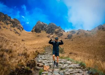
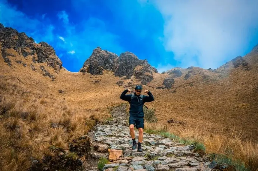
The official section of the Inca Trail is about 26 miles. On paper, it might seem like a manageable distance, but each section of the route has its challenge. The start is in a temperate valley at around 8,850 feet elevation. As you advance, the oxygen decreases and your legs feel the incline. The highest point is Warmiwañusca, at about 13,780 feet. It helps a lot to arrive with some training and respect the rest breaks while ascending slowly.
Over four days, the landscape changes many times. You go from open, high puna areas covered in dry grasslands of the mountains to cloud forest zones with giant ferns, moss-covered trees, and orchids.
In the high parts, it’s possible to see Andean condors gliding over the valleys if the weather cooperates. In more temperate sections, vizcachas often appear on the rocks, Andean deer quickly crossing through bushes, and Andean foxes near the campsites. In the cloud forest zones, it’s common to see hummingbirds, large butterflies, and colorful birds. Although rare, the sanctuary also harbors species like the cock-of-the-rock and the spectacled bear, which sometimes show themselves from a distance or even at Machu Picchu itself.
Fortresses in the Mist
Besides the altitude and landscape, the archaeological sites that appear along the route are impressive. Patallacta shows agricultural terraces that allowed farming on very steep slopes. Runkurakay rises like a circular tower that guarded the passage to the upper valleys. Sayacmarca seems to hang from the mountain, and its position explains why it was an important control point.
Phuyupatamarca lives almost always among clouds. Its ceremonial baths preserve water channels that still function after centuries. Wiñay Wayna is the great final complex before reaching Machu Picchu. It brings together temples, fountains, and terraces that integrate with the vegetation as if they had grown alongside the mountain. For many people, it’s the place where history stops being a topic in books and becomes something you can experience firsthand.
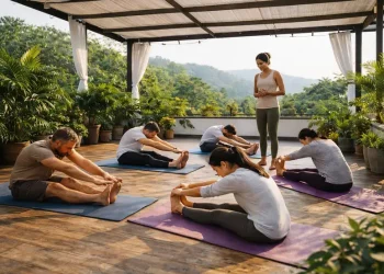
Walking Is Also Health
The Inca Trail can become a profound experience for body and mind if approached with respect.
Walking several days on irregular terrain can help improve heart endurance and strengthen legs, glutes, and back. The ancient steps activate muscles we barely use in daily life. Balance improves because the path has constant changes in level. Posture corrects itself naturally when you carry a light backpack and lean on trekking poles.
The mental effect can also be strong for many people. Four days with fewer screens, a slower pace, and very clear tasks may help reduce anxiety and mental noise. Many people report sleeping better, breathing more calmly, and returning with their thoughts more organized. The altitude conditions may require people to pay attention to breathing. You may need to inhale deeply, exhale completely, and find a rhythm your body can tolerate. That practice can later be used in the city to manage stress.
Preparing Smart
To arrive well, it’s good to settle in for two or three days in the city of Cusco before the trek. That way, your body starts adapting to the lower oxygen levels. It’s important to hydrate constantly, eat light, avoid alcohol, and listen to your body’s signals. If someone feels intense headache, nausea, or unusual fatigue, it’s best to tell the guide.
People with respiratory, cardiac, or metabolic conditions should not treat altitude as just another travel detail. Above 10,000 or 13,000 feet, the heart works faster, the lungs receive less oxygen, and the body enters a demand that’s not the same as at sea level. That’s why it’s not enough to simply “see how it goes.” It’s important to talk with a doctor before booking, explain that it involves several days of walking at altitude, and ask for a clear opinion on whether it’s safe to do it and under what conditions.
This information is general and only offers a basic idea of what walking at altitude involves. Each person has a different body and medical history. If someone has a specific condition or plans to travel to this area, they should definitely consult a health professional. Nothing mentioned here replaces an actual medical evaluation.
Choosing the Right Season
The time of year changes the experience quite a bit. Between April and October, the weather tends to be more stable, the skies are clear, and the nights are cold. The views are wide, and there are more people on the route. Between November and March, rainfall increases, the trails can become slippery, the mountains turn greener, and the mist gives a more mysterious air to the ruins. Each traveler can choose based on their tolerance for cold, rain, and crowds.
The Inca Trail is a demanding hike. It requires physical and mental preparation. Even something as simple as choosing good hiking boots can make a difference in the comfort and safety of the journey. History is under your feet, walking the same paths that generations used centuries ago.
Walking with an experienced local operator also helps the journey feel clearer and more manageable, especially in the logistical parts that the traveler doesn’t see. History is under your feet, following the same paths that generations used centuries ago. When you reach the Sun Gate and see Machu Picchu emerge from the clouds, you understand why so many people remember this trip as an important moment in their relationship with the mountain, with their body, and with their own life.
Disclaimer:
This article provides general information about trekking, altitude conditions, and physical wellness for educational purposes only. It is not medical advice, diagnosis, treatment, or a substitute for consultation with a licensed healthcare professional. High-altitude activities, including the Inca Trail to Machu Picchu, may involve physical risks that vary widely between individuals. Readers should always seek guidance from a qualified doctor before engaging in strenuous travel, trekking, or activities at elevations above normal living conditions.
WellHealthOrganic.com is not run by doctors, licensed medical practitioners, or certified mountain experts. Nothing in this article guarantees safety, fitness readiness, or prevention of altitude-related illness. Any physical, mental, or health benefits mentioned are general observations and not assured outcomes. Readers are solely responsible for evaluating their own health, limitations, and preparedness before participating in any trekking or adventure activity.
Information in this article is based on publicly available sources and general understanding. We do not endorse, verify, or recommend any specific trekking company, service provider, tour operator, or external website mentioned. Any outgoing link is provided only for general reference; inclusion does not imply endorsement, medical advice, or promotional intent, nor does it guarantee reliability, accuracy, or safety.
WellHealthOrganic.com and the authors disclaim all liability for injuries, altitude sickness, health complications, travel decisions, equipment failures, or any loss or damages that may result from following, relying on, or acting upon the information in this article. All images used in this post are for illustrative reference only and should not be interpreted as professional guidance, guaranteed results, or real-time environmental conditions.
By reading or using this content, you agree that all decisions related to travel, trekking, fitness, and health are entirely your own responsibility, and WellHealthOrganic.com shall not be held liable for any consequences, harm, or loss arising from its use.